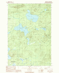
1989 Map of Spider Lake
USGS Topo · Published 1989About this map
Pleasant Lake and Spider Lake dominate this Piscataquis County landscape, a region defined by its complex hydrology and timber-management history. Situated within the Allagash Wilderness State Waterway, the map reveals a remote network of drainage systems including Pleasant Stream and several branches of Soper Brook. The terrain is marked by prominent elevations such as Harrow Mountain and Soper Mountain, which rise sharply above the interconnected ponds. The absence of public infrastructure is underscored by the numerous trails and access points labeled as private, indicating a territory largely dedicated to industrial forestry or private recreation during the late twentieth century. Smaller water bodies like Leadbetter Pond, Grass Pond, and the Upper Portage and Lower Portage ponds suggest historical transit routes through the Maine woods. A single Gravel Pit near Spider Lake serves as a rare indicator of human extractive activity in this otherwise primitive forest setting.
Find a feature on this map
31 named features on this map. Tap any name to fly to it.
Don’t see what you’re looking for? This feature index may not catch every label — zoom into the map to look around manually.
Map Details
Editions of this 1989 Spider Lake Map
This is the sole edition of this map. No revisions or reprints were ever made.
Other maps of this area

1932 · Umsaskis Lake
USGS Topo · 1:48,000

1932 · Musquacook Lakes
USGS Topo · 1:48,000

1935 · Umsaskis Lake
USGS Topo · 1:62,500

1935 · Musquacook Lakes
USGS Topo · 1:62,500

1954 · Spider Lake
USGS Topo · 1:62,500

1954 · Churchill Lake
USGS Topo · 1:62,500

1954 · Presque Isle
USGS Topo · 1:250,000

1958 · Presque Isle
USGS Topo · 1:250,000

1960 · Presque Isle
USGS Topo · 1:250,000

1961 · Spider Lake
USGS Topo · 1:62,500