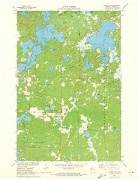
1971 Map of Spider Lake
USGS Topo · Published 1973About this map
Chequamegon National Forest defines the lake-strewn landscape of this Sawyer County region during the early 1970s. The map reveals an intricate network of glacial water bodies, from the sprawling reach of Spider Lake to smaller basins like Whiplash Lake and One Shoe Lake. Modern depth curves provide underwater topography for several lakes, reflecting a period of active natural resource management by the Wisconsin Department of Natural Resources. Human activity is centered around the Townhall and a sparse grid of local roads like Sportsman Road and Townhall Road. To the south, the Tiger Cat Flowage is controlled by the Tiger Cat Dam, while the Chief River State Wildlife Management Area preserves the wetland corridor along the Chief River Road. This survey documents a quiet era of recreational development and forest conservation before the intensification of modern lakeside estates.
Find a feature on this map
54 named features on this map. Tap any name to fly to it.
Don’t see what you’re looking for? This feature index may not catch every label — zoom into the map to look around manually.
Map Details
Editions of this 1971 Spider Lake Map
This is the sole edition of this map. No revisions or reprints were ever made.
Other maps of this area

1943 · Namekagon Lake
USGS Topo · 1:48,000

1944 · Couderay
USGS Topo · 1:48,000

1944 · Radisson
USGS Topo · 1:48,000

1944 · Hayward
USGS Topo · 1:48,000

1945 · Namekagon Lake
USGS Topo · 1:48,000

1948 · Couderay
USGS Topo · 1:48,000

1949 · Radisson
USGS Topo · 1:48,000

1953 · Ashland
USGS Topo · 1:250,000

1953 · Rice Lake
USGS Topo · 1:250,000

1958 · Ashland
USGS Topo · 1:250,000