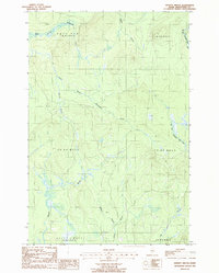
1986 Map of Spinney Brook
USGS Topo · Published 1987About this map
The North Branch Blackwater River and South Branch Blackwater River define this deeply wooded portion of Aroostook County, where the landscape is organized by township and range lines rather than incorporated towns. In the mid-1980s, this area remained largely defined by its hydrological network, including Spinney Brook and the W Br Presque Isle Str. The presence of a Gravel Pit and names like Tie Camp Brook and Boom Branch point to the region's history of logging and resource extraction. Spanning townships such as Squapan and Saint Croix, the map reveals a terrain of brooks and seasonal drainages including Beaver Brook and Bogan Brook. This survey provides a look at the remote interior of Northern Maine before modern development, capturing the essential character of the North Woods.
Find a feature on this map
16 named features on this map. Tap any name to fly to it.
Don’t see what you’re looking for? This feature index may not catch every label — zoom into the map to look around manually.
Map Details
Editions of this 1986 Spinney Brook Map
This is the sole edition of this map. No revisions or reprints were ever made.
Other maps of this area

1931 · Ashland
USGS Topo · 1:48,000

1934 · Ashland
USGS Topo · 1:62,500

1935 · Howe Brook
USGS Topo · 1:48,000

1935 · Presque Isle
USGS Topo · 1:62,500

1939 · Howe Brook
USGS Topo · 1:62,500

1940 · Oxbow
USGS Topo · 1:62,500

1942 · Oxbow
USGS Topo · 1:62,500

1953 · Ashland
USGS Topo · 1:62,500

1953 · Presque Isle
USGS Topo · 1:62,500

1954 · Howe Brook
USGS Topo · 1:62,500