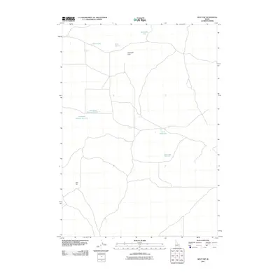
2010 Map of Split Top
USGS Topo · Published 2010About this map
Split Top and Packsaddle Butte dominate this section of the Idaho landscape, providing the primary topographic relief in a region defined by its scattered water resources. This 2010 survey illustrates a complex network of local roads and 4WD tracks that connect various isolated water bodies, suggesting a land used for seasonal grazing or remote recreation. Significant water management features include Houghland Reservoir Number 1 and Houghland Reservoir Number 2, along with Clear Lake Reservoir to the southeast. These man-made and natural catchments, such as Gentle Horse Lake and Packsaddle Lake, are critical markers for anyone navigating the high desert environment. The map provides a clear picture of the modern rural infrastructure, showing how water storage and transport routes are oriented around the significant peaks of the Split Top quadrangle.
Find a feature on this map
9 named features on this map. Tap any name to fly to it.
Don’t see what you’re looking for? This feature index may not catch every label — zoom into the map to look around manually.
Map Details
Editions of this 2010 Split Top Map
This is the sole edition of this map. No revisions or reprints were ever made.
Other maps of this area

1955 · Idaho Falls
USGS Topo · 1:250,000

1958 · Idaho Falls
USGS Topo · 1:250,000

1972 · Antelope Lake
USGS Topo · 1:24,000

1972 · Split Top
USGS Topo · 1:24,000

1972 · Mosby Well
USGS Topo · 1:24,000

1972 · Mosby Butte
USGS Topo · 1:24,000

1972 · Sunset Lake
USGS Topo · 1:24,000

1972 · Serviceberry Butte
USGS Topo · 1:24,000

1973 · Rock Butte
USGS Topo · 1:24,000
1973 · Coffee Point SW
USGS Topo · 1:24,000