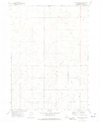
1973 Map of Coffee Point SW
USGS Topo · Published 1976About this map
This high-desert expanse in Bingham County, Idaho, is defined by a sparse network of section lines and isolated infrastructure characteristic of the Snake River Plain. During the early 1970s, the primary evidence of human activity in this arid landscape was a series of deep water extraction points. The map meticulously records the locations of numerous wells scattered across the sagebrush and lava fields, marking the essential water sources that supported livestock or early agricultural attempts in this dry environment. These features, often the only named landmarks for miles, follow the rigid geometry of public land surveys and agricultural development in a region where surface water is notably absent.
Find a feature on this map
1 named feature on this map. Tap any name to fly to it.
Don’t see what you’re looking for? This feature index may not catch every label — zoom into the map to look around manually.
Map Details
Editions of this 1973 Coffee Point SW Map
This is the sole edition of this map. No revisions or reprints were ever made.
Other maps of this area

1934 · American Falls
USGS Topo · 1:62,500

1936 · American Falls
USGS Topo · 1:62,500

1954 · Pocatello
USGS Topo · 1:250,000

1955 · Idaho Falls
USGS Topo · 1:250,000

1958 · Idaho Falls
USGS Topo · 1:250,000

1958 · Pocatello
USGS Topo · 1:250,000
1971 · Aberdeen
USGS Topo · 1:24,000

1971 · American Falls NW
USGS Topo · 1:24,000

1972 · Split Top
USGS Topo · 1:24,000

1972 · Mosby Well
USGS Topo · 1:24,000