1971 Map of Aberdeen
USGS Topo · Published 1974About this map
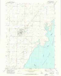
Aberdeen stands as a central agricultural hub on this 1970s survey, surrounded by a complex network of irrigation infrastructure including the High Line Canal and the Low Line Canal. The landscape is defined by the intersection of water management and transport, with the Union Pacific railroad passing through the northern settlement of Fingal and into the heart of town. Local industry is clearly marked by the presence of a Grain Elevator, Storage Bins, and the Agricultural Experiment Station (U of Idaho), which speaks to the region's specialized farming history.
Find a feature on this map
30 named features on this map. Tap any name to fly to it.
Don’t see what you’re looking for? This feature index may not catch every label — zoom into the map to look around manually.
Map Details
Editions of this 1971 Aberdeen Map
This is the sole edition of this map. No revisions or reprints were ever made.
Other maps of this area

1934 · American Falls
USGS Topo · 1:62,500

1934 · Michaud
USGS Topo · 1:62,500

1936 · American Falls
USGS Topo · 1:62,500

1937 · Michaud
USGS Topo · 1:62,500

1954 · Pocatello
USGS Topo · 1:250,000
1955 · Springfield
USGS Topo · 1:24,000

1955 · Idaho Falls
USGS Topo · 1:250,000

1958 · Idaho Falls
USGS Topo · 1:250,000

1958 · Pocatello
USGS Topo · 1:250,000
1971 · Schiller
USGS Topo · 1:24,000