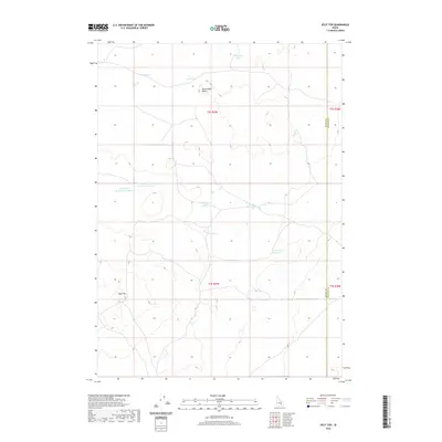
2020 Map of Split Top
USGS Topo · Published 2020About this map
The high high-desert terrain of Bingham County and Blaine County is defined by its collection of isolated water sources and volcanic landmarks. Split Top and Packsaddle Butte rise as the primary geographical anchors in a landscape dominated by the management of scarce water resources. This high-altitude hydrology is evident in the clustered names of basins and impoundments, including Binder Lake, Wild Horse Lake, and the larger Clear Lake Reservoir. The presence of the Blaine Co Bingham Co boundary line cutting through this territory highlights the jurisdictional divisions of these remote western uplands. Mapping of the Houghland Reservoir Number 1 and Houghland Reservoir Number 2 suggests a history of localized water engineering for stock or land use in an otherwise arid environment, where Gentle Horse Lake and South Lake provide critical reference points in the open country.
Find a feature on this map
16 named features on this map. Tap any name to fly to it.
Don’t see what you’re looking for? This feature index may not catch every label — zoom into the map to look around manually.
Map Details
Editions of this 2020 Split Top Map
This is the sole edition of this map. No revisions or reprints were ever made.
Other maps of this area

1955 · Idaho Falls
USGS Topo · 1:250,000

1958 · Idaho Falls
USGS Topo · 1:250,000

1972 · Antelope Lake
USGS Topo · 1:24,000

1972 · Split Top
USGS Topo · 1:24,000

1972 · Mosby Well
USGS Topo · 1:24,000

1972 · Mosby Butte
USGS Topo · 1:24,000

1972 · Sunset Lake
USGS Topo · 1:24,000

1972 · Serviceberry Butte
USGS Topo · 1:24,000

1973 · Rock Butte
USGS Topo · 1:24,000
1973 · Coffee Point SW
USGS Topo · 1:24,000