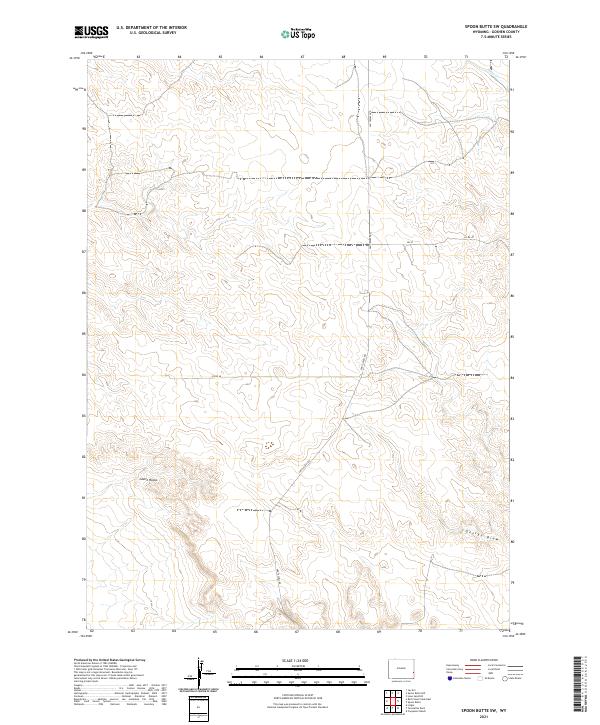
2021 Map of Spoon Butte SW
USGS Topo · Published 2021About this map
Castle Rocks stands as a prominent landmark in this high plains landscape of Goshen County, where the terrain transitions from undulating rises into defined drainages. The area is characterized by a sparse, ranch-oriented infrastructure, anchored by the north-south transit of Van Tassell Rd and local connectors like Co Rd 40. Natural hydrology is represented by the intermittent flow of Sheep Cr in the northeast corner and the winding course of George Draw to the southeast. These features, along with the precise Section, Township, and Range lines of the Public Land Survey System, reflect the enduring grid-based settlement patterns of eastern Wyoming. This 2021 update documents the continued reliance on legacy road networks and natural landmarks in a region defined more by its landforms than by concentrated urban development.
Find a feature on this map
16 named features on this map. Tap any name to fly to it.
Don’t see what you’re looking for? This feature index may not catch every label — zoom into the map to look around manually.
Map Details
Editions of this 2021 Spoon Butte SW Map
This is the sole edition of this map. No revisions or reprints were ever made.
Other maps of this area

1896 · Patrick
USGS Topo · 1:125,000

1954 · Torrington
USGS Topo · 1:250,000

1958 · Torrington
USGS Topo · 1:250,000
1963 · Lingle
USGS Topo · 1:24,000

1963 · Tea Kettle Rock
USGS Topo · 1:24,000
1963 · Carpenter Ranch
USGS Topo · 1:24,000

1974 · Spoon Butte SW
USGS Topo · 1:24,000

1974 · Jay Em
USGS Topo · 1:24,000

1974 · Spoon Butte
USGS Topo · 1:24,000
1977 · Red Cloud Creek East
USGS Topo · 1:24,000