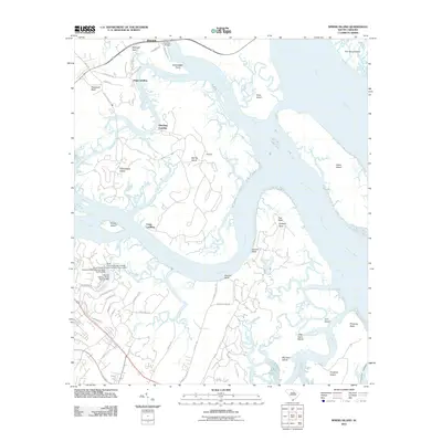
2011 Map of Spring Island
USGS Topo · Published 2011About this map
Victoria Bluff and the winding reaches of the Colleton River dominate this coastal landscape at the start of the 2010s. The map illustrates a complex network of tidal waterways and marsh-fronted islands, including the namesake Spring Island and Callawassie Island. Historic landings such as Fripp Landing, Pinckney Landing, and Copp Landing indicate a long-standing reliance on water access for the various necks of land, while the G G Dowling Bridge provides a modern highway link over the Chechessee River. To the south, emerging residential development is evident in the street grids near Victoria Bluff and the Sawmill Creek drainage, contrasting with the undeveloped expanses of Pinckney Island and Daws Island. Small settlements like Riverdale and Edwards sit near the northern and central reaches, while the Intracoastal Waterway skirts the southeastern edge along Skull Cr.
Find a feature on this map
62 named features on this map. Tap any name to fly to it.
Don’t see what you’re looking for? This feature index may not catch every label — zoom into the map to look around manually.
Map Details
Editions of this 2011 Spring Island Map
This is the sole edition of this map. No revisions or reprints were ever made.
Other maps of this area

1920 · Okatie
USGS Topo · 1:62,500

1920 · Hilton Head
USGS Topo · 1:62,500

1920 · Bluffton
USGS Topo · 1:62,500

1942 · Okatie
USGS Topo · 1:62,500

1944 · Fort Fremont
USGS Topo · 1:62,500

1945 · Bluffton
USGS Topo · 1:62,500

1945 · Hilton Head
USGS Topo · 1:62,500

1947 · Savannah
USGS Topo · 1:250,000

1948 · Savannah
USGS Topo · 1:250,000
1955 · Pritchardville
USGS Topo · 1:24,000