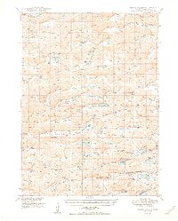
1950 Map of Spring Valley
USGS Topo · Published 1950About this map
The Nebraska Sandhills in western Grant County are defined here by an intricate network of basins and valleys that supported a mid-century ranching economy. This landscape is marked by numerous natural catchments and aquifers, as evidenced by the high concentration of Flowing Well labels and prominent water bodies like Long Lake, Moran Lake, and Spring Valley Lake. The settlement pattern follows these low-lying areas, with several named valleys such as Handlin Valley, Pratt Valley, and Vinton Valley serving as the primary corridors for travel and habitation.
Find a feature on this map
34 named features on this map. Tap any name to fly to it.
Don’t see what you’re looking for? This feature index may not catch every label — zoom into the map to look around manually.
Map Details
Editions of this 1950 Spring Valley Map
2 editions found
Other maps of this area

1948 · Ashby
USGS Topo · 1:62,500

1948 · Carr Lake
USGS Topo · 1:62,500

1948 · George Lake
USGS Topo · 1:62,500

1948 · Whitman
USGS Topo · 1:62,500

1948 · Spring Valley
USGS Topo · 1:62,500

1949 · Arthur
USGS Topo · 1:62,500

1949 · Ashby
USGS Topo · 1:62,500

1949 · Flats
USGS Topo · 1:62,500

1950 · Flats
USGS Topo · 1:62,500

1950 · Spring Valley
USGS Topo · 1:62,500