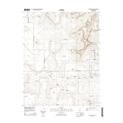
2014 Map of Springdale West
USGS Topo · Published 2014About this map
Grafton and Rockville anchor the river valley on this modern study of southwestern Utah's canyon country. The Virgin River carves a central path through the landscape, flanked by significant landmarks such as Grafton Mesa and the Rockville Bench. To the east, the gateway to Zion National Park is marked by the high elevations of The West Temple and Mt Kinesava. Genealogists will find the locations of the Grafton Cem, Rockville Cem, and Springdale Cem preserved here, serving as quiet markers of the early agricultural communities that took root along the river. The map also records the precise terrain of the Petrified Forest and the Obert C Tanner Amphitheater, illustrating the transition from agricultural valley floor to the dramatic vertical formations of Zion Canyon.
Find a feature on this map
55 named features on this map. Tap any name to fly to it.
Don’t see what you’re looking for? This feature index may not catch every label — zoom into the map to look around manually.
Map Details
Editions of this 2014 Springdale West Map
This is the sole edition of this map. No revisions or reprints were ever made.
Other maps of this area

1885 · St. George
USGS Topo · 1:250,000

1886 · Kanab
USGS Topo · 1:250,000

1891 · St. George
USGS Topo · 1:250,000

1953 · Cedar City
USGS Topo · 1:250,000

1954 · La Verkin 4 SE
USGS Topo · 1:24,000

1954 · La Verkin 4 NW
USGS Topo · 1:24,000

1954 · La Verkin 4 SW
USGS Topo · 1:24,000

1954 · La Verkin 1 SW
USGS Topo · 1:24,000
1956 · Springdale SW
USGS Topo · 1:24,000

1958 · Cedar City
USGS Topo · 1:250,000