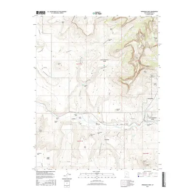
2017 Map of Springdale West
USGS Topo · Published 2017About this map
Grafton sits as a notable cultural site along the Virgin River, representing the early settlement patterns of Washington County. This 2017 survey details the transition from the river valley floors to the dramatic sandstone formations of Zion National Park, where landmarks like the Altar of Sacrifice and the Towers of the Virgin dominate the northern skyline. The map tracks the convergence of several major drainages, including Dalton Wash and Coalpits Wash, which have historically shaped the accessibility of the region's mesas. Genealogists will find the locations of the Grafton Cem, Rockville Cem, and the Springdale Jolley-Gifford Cem particularly valuable for tracing local pioneer history. From the Rockville Bench to the Gooseberry Mesa, the topography illustrates a landscape defined by sharp elevation changes and high desert plateaus.
Find a feature on this map
63 named features on this map. Tap any name to fly to it.
Don’t see what you’re looking for? This feature index may not catch every label — zoom into the map to look around manually.
Map Details
Editions of this 2017 Springdale West Map
This is the sole edition of this map. No revisions or reprints were ever made.
Other maps of this area

1885 · St. George
USGS Topo · 1:250,000

1886 · Kanab
USGS Topo · 1:250,000

1891 · St. George
USGS Topo · 1:250,000

1953 · Cedar City
USGS Topo · 1:250,000

1954 · La Verkin 4 SE
USGS Topo · 1:24,000

1954 · La Verkin 4 NW
USGS Topo · 1:24,000

1954 · La Verkin 4 SW
USGS Topo · 1:24,000

1954 · La Verkin 1 SW
USGS Topo · 1:24,000
1956 · Springdale SW
USGS Topo · 1:24,000

1958 · Cedar City
USGS Topo · 1:250,000