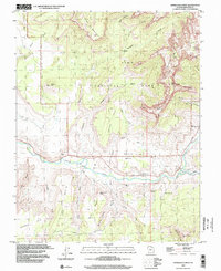
1999 Map of Springdale West
USGS Topo · Published 2002About this map
Grafton and Rockville anchor the fertile river valley on this late-twentieth-century study of the border between high plateau and deep canyon. The Virgin River is the primary artery here, joined by the North Fork Virgin River and East Fork Virgin River near Springdale. To the north, the terrain rises sharply into Zion National Park, marked by colossal features like The West Temple, The Sundial, and the Altar of Sacrifice. The settlement pattern follows the water, with a Cem located near Grafton and various landforms like Rockville Bench and Smith Mesa defining the habitable spaces above the riverbed. The map also records specialized routes such as the Petrified Forest Trail and a Jeep Trail crossing Grafton Mesa, reflecting the area's mix of remote ranching history and emerging recreational access.
Find a feature on this map
43 named features on this map. Tap any name to fly to it.
Don’t see what you’re looking for? This feature index may not catch every label — zoom into the map to look around manually.
Map Details
Editions of this 1999 Springdale West Map
This is the sole edition of this map. No revisions or reprints were ever made.
Other maps of this area

1885 · St. George
USGS Topo · 1:250,000

1886 · Kanab
USGS Topo · 1:250,000

1891 · St. George
USGS Topo · 1:250,000

1953 · Cedar City
USGS Topo · 1:250,000

1954 · La Verkin 4 SE
USGS Topo · 1:24,000

1954 · La Verkin 4 NW
USGS Topo · 1:24,000

1954 · La Verkin 4 SW
USGS Topo · 1:24,000

1954 · La Verkin 1 SW
USGS Topo · 1:24,000
1956 · Springdale SW
USGS Topo · 1:24,000

1958 · Cedar City
USGS Topo · 1:250,000