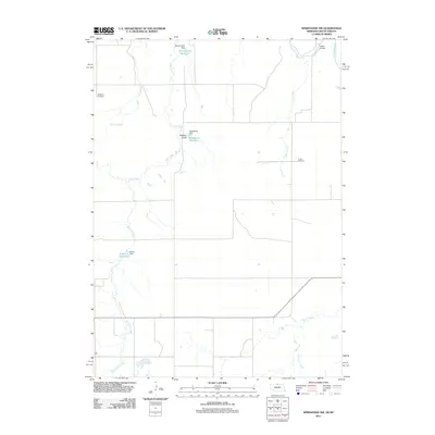
2011 Map of Springview NW
USGS Topo · Published 2011About this map
The Keya Paha River winds through the northeast corner of this Keya Paha County landscape, crossed by the Dubel Bridge. This rural Nebraska terrain is defined by a dendritic network of drainages, including Burton Creek, Jordan Creek, and Jimmie Creek, which feed into larger systems or smaller local catchments. The distribution of man-made water features such as Bloomstrom Reservoir, Kappelman Reservoir, and Sloan Reservoir indicates a reliance on managed water resources for agriculture and ranching in this part of the Great Plains.
Find a feature on this map
16 named features on this map. Tap any name to fly to it.
Don’t see what you’re looking for? This feature index may not catch every label — zoom into the map to look around manually.
Map Details
Editions of this 2011 Springview NW Map
This is the sole edition of this map. No revisions or reprints were ever made.
Other maps of this area

1950 · Meadville
USGS Topo · 1:24,000

1955 · Mitchell
USGS Topo · 1:250,000

1955 · O'Neill
USGS Topo · 1:250,000

1959 · O'Neill
USGS Topo · 1:250,000

1959 · Mitchell
USGS Topo · 1:250,000

1964 · Dallas SW
USGS Topo · 1:24,000
1964 · Springview
USGS Topo · 1:24,000

1964 · Paxton
USGS Topo · 1:24,000
1964 · Burton
USGS Topo · 1:24,000
1964 · Springview SE
USGS Topo · 1:24,000