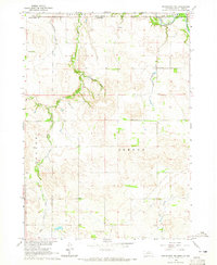
1964 Map of Springview NW
USGS Topo · Published 1965About this map
The Keya Paha River winds through the northern portion of this landscape, marking a significant geographic and political threshold at the South Dakota Nebraska border. This mid-1960s survey documents a sparsely settled ranching and farming area within Burton township, where the terrain is defined by the deep incisions of Deckers Gulch and the drainage network of Holt Creek and its branches.
Find a feature on this map
17 named features on this map. Tap any name to fly to it.
Don’t see what you’re looking for? This feature index may not catch every label — zoom into the map to look around manually.
Map Details
Editions of this 1964 Springview NW Map
This is the sole edition of this map. No revisions or reprints were ever made.
Other maps of this area

1950 · Meadville
USGS Topo · 1:24,000

1955 · Mitchell
USGS Topo · 1:250,000

1955 · O'Neill
USGS Topo · 1:250,000

1959 · O'Neill
USGS Topo · 1:250,000

1959 · Mitchell
USGS Topo · 1:250,000

1964 · Dallas SW
USGS Topo · 1:24,000
1964 · Springview
USGS Topo · 1:24,000

1964 · Paxton
USGS Topo · 1:24,000
1964 · Burton
USGS Topo · 1:24,000
1964 · Springview SE
USGS Topo · 1:24,000