
Loading...
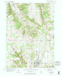
Loading map...2023 Map of Springville
USGS Topo · Published 2023About this map
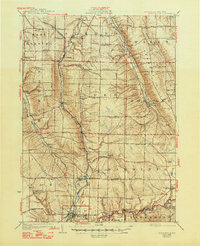
Springville serves as the primary hub of this landscape, situated at the confluence of local routes like W Main St and S Cascade Dr. The village is surrounded by a series of distinct upland hills and hollows, most notably Townsend Hill, South Hill, and the corridor of Hayes Hollow. The region is defined by its complex drainage network, where Eighteenmile Creek and Spooner Creek carve through the terrain alongside smaller tributaries like Landon Brook and Crump Brook.
Find a feature on this map
97 named features on this map. Tap any name to fly to it.
Don’t see what you’re looking for? This feature index may not catch every label — zoom into the map to look around manually.
Map Details
Date Portrayed2023
Date Published2023
PublisherU.S. Geological Survey
Map TypeTopographic
Scale1:24000
Physical Dimensions24 x 29 inches
Editions of this 2023 Springville Map
This is the sole edition of this map. No revisions or reprints were ever made.
Historical Maps of East Concord Through Time
3 maps found
Featured Locations
Source Details
SourceU.S. Geological Survey
CopyrightPublic Domain