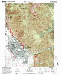
1998 Map of Springville
USGS Topo · Published 2000About this map
Springville and Mapleton sit at the foot of the Wasatch Range, where the steep topography of the Uinta National Forest meets the developed bench of the Utah Valley. This late 20th-century revision captures a community defined by its civic and educational infrastructure, from the Springville Middle Sch and Art City Sch to the Museum and City Hall. The eastern mountain front is marked by dramatic drainages like Hobble Creek and Slate Canyon, rising toward peaks such as Provo Peak and Ether Peak. Industrial and recreational features are interspersed throughout the valley floor, including the Union Pacific rail corridor, the State Fish Hatchery, and the Hobble Creek Golf Course. Local history is anchored by landmarks like the City Cem and Evergreen Cem, alongside family and community spaces like Kellys Grove Park and the Rodeo Grounds.
Find a feature on this map
97 named features on this map. Tap any name to fly to it.
Don’t see what you’re looking for? This feature index may not catch every label — zoom into the map to look around manually.
Map Details
Editions of this 1998 Springville Map
This is the sole edition of this map. No revisions or reprints were ever made.
Other maps of this area

1885 · Salt Lake
USGS Topo · 1:250,000

1907 · Strawberry Valley
USGS Topo · 1:125,000

1909 · Strawberry Valley
USGS Topo · 1:125,000

1948 · Spanish Fork
USGS Topo · 1:24,000

1948 · Orem
USGS Topo · 1:24,000

1948 · Orem
USGS Topo · 1:62,500

1948 · Springville
USGS Topo · 1:24,000

1948 · Provo
USGS Topo · 1:24,000

1948 · Bridal Veil Falls
USGS Topo · 1:24,000

1949 · Provo
USGS Topo · 1:62,500