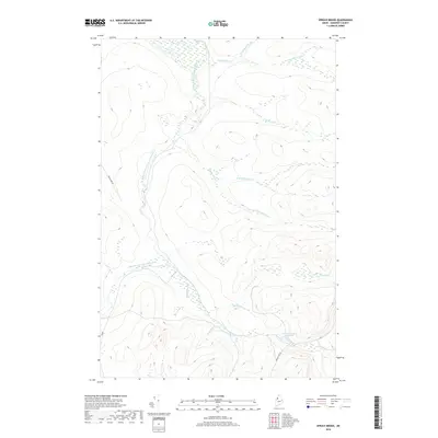
2018 Map of Spruce Brook
USGS Topo · Published 2018About this map
The Baker Branch Saint John River winds through this heavily forested section of Saint John Township, defining a landscape shaped by an intricate network of waterways. In this remote part of Somerset County, the terrain is characterized by the confluence of numerous tributaries including Campbell Brook, Spruce Brook, and Trout Brook. Evidence of the region's managed timberlands is visible through a system of unpaved access ways such as Baker Lake Rd, Russell Mt Rd, and the numbered 490 Rd. The southeastern portion of the map is notable for the Loon Stream Deadwater, a distinct widening of Loon Stream that illustrates the slow-moving, marshy drainage patterns common to the Maine North Woods. This survey provides a precise look at the hydrology of the upper Saint John watershed, where brooks like Lost Pond Brook and Post Brook drain the high ground between these vital timber transport routes.
Find a feature on this map
17 named features on this map. Tap any name to fly to it.
Don’t see what you’re looking for? This feature index may not catch every label — zoom into the map to look around manually.
Map Details
Editions of this 2018 Spruce Brook Map
This is the sole edition of this map. No revisions or reprints were ever made.
Other maps of this area

1954 · Baker Lake
USGS Topo · 1:62,500

1954 · Caucomgomoc Lake
USGS Topo · 1:62,500

1954 · Allagash Lake
USGS Topo · 1:62,500

1954 · St. John Pond
USGS Topo · 1:62,500

1954 · Presque Isle
USGS Topo · 1:250,000

1958 · Presque Isle
USGS Topo · 1:250,000

1958 · Caucomgomoc Lake
USGS Topo · 1:62,500

1958 · Saint John Pond
USGS Topo · 1:62,500

1960 · Presque Isle
USGS Topo · 1:250,000

1961 · Allagash Lake
USGS Topo · 1:62,500