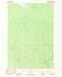
1989 Map of Spruce Brook
USGS Topo · Published 1989About this map
Baker Branch St John River defines the western landscape of this Somerset County territory in the late 1980s, where the Maine woods are marked by an intricate network of drainage and timber access. The map reveals the hydrology of the North Woods, anchored by Loon Stream Deadwater and the confluence of Spruce Brook and Higgins Brook. While the area remains largely undeveloped, industrial activity is noted by several extraction sites, including a Shale Pit and multiple Gravel Pits used for road maintenance. A series of private roads and township boundaries, such as T 7 R 16 W E L S, provide a structured look at how this remote logging country was managed. From Lost Pond to the wide reaches of the Loon Stream, the terrain is a study in river-fed wetlands and seasonal stream flow typical of the Maine interior.
Find a feature on this map
26 named features on this map. Tap any name to fly to it.
Don’t see what you’re looking for? This feature index may not catch every label — zoom into the map to look around manually.
Map Details
Editions of this 1989 Spruce Brook Map
This is the sole edition of this map. No revisions or reprints were ever made.
Other maps of this area

1954 · Baker Lake
USGS Topo · 1:62,500

1954 · Caucomgomoc Lake
USGS Topo · 1:62,500

1954 · Allagash Lake
USGS Topo · 1:62,500

1954 · St. John Pond
USGS Topo · 1:62,500

1954 · Presque Isle
USGS Topo · 1:250,000

1958 · Presque Isle
USGS Topo · 1:250,000

1958 · Caucomgomoc Lake
USGS Topo · 1:62,500

1958 · Saint John Pond
USGS Topo · 1:62,500

1960 · Presque Isle
USGS Topo · 1:250,000

1961 · Allagash Lake
USGS Topo · 1:62,500