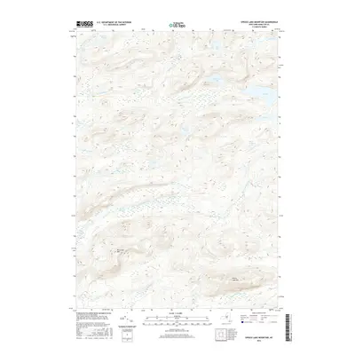
2016 Map of Spruce Lake Mountain
USGS Topo · Published 2016About this map
Spruce Lake Mtn and W Canada Mtn dominate this high-elevation interior landscape within the Adirondacks. The area is defined by an intricate network of glacial lakes and mountain streams, centered on the drainage of West Canada Creek and its distinctive features like First Stillwater and Second Stillwater. This 2016 survey documents a region nearly devoid of human infrastructure, focusing instead on the complex topography and hydrography that shapes the backcountry. Significant water bodies such as Brooktrout Lake, Northrup Lake, and the remote Mica Lakes are connected by numerous smaller tributaries including Wolf Cr and Muskrat Cr. The mapping of these remote waters and peaks provides essential detail for those navigating or studying the hydrologic patterns of the Indian River headwaters and the surrounding wilderness peaks.
Find a feature on this map
23 named features on this map. Tap any name to fly to it.
Don’t see what you’re looking for? This feature index may not catch every label — zoom into the map to look around manually.
Map Details
Editions of this 2016 Spruce Lake Mountain Map
This is the sole edition of this map. No revisions or reprints were ever made.
Other maps of this area

1900 · Canada Lake
USGS Topo · 1:62,500

1900 · Wilmurt
USGS Topo · 1:62,500

1901 · Old Forge
USGS Topo · 1:62,500

1902 · Wilmurt
USGS Topo · 1:62,500

1903 · West Canada Lakes
USGS Topo · 1:62,500

1904 · Piseco Lake
USGS Topo · 1:62,500

1906 · Piseco Lake
USGS Topo · 1:62,500

1908 · Piseco Lake
USGS Topo · 1:62,500

1950 · Utica
USGS Topo · 1:250,000
1954 · Ohio
USGS Topo · 1:62,500