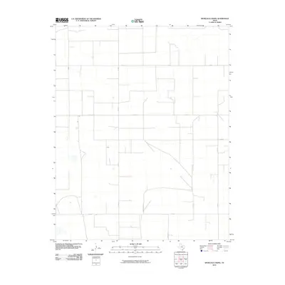
2010 Map of Spurlock Chapel
USGS Topo · Published 2010About this map
Sherman County agriculture and rural infrastructure define this portion of the Texas Panhandle during the early 21st century. The landscape is organized by a precise grid of farm-to-market and county roads, reflecting the large-scale ranching and farming operations typical of the High Plains. Fm 1573 serves as the primary east-west artery through the southern portion of the quadrangle, while Hudson Rd and Hudson Boost Rd provide essential vertical connectivity. These routes, along with numbered corridors like Co Rd 13 and Co Rd 17, trace the property boundaries and section lines that have dictated land use in this region for generations. The intermittent drainage patterns and scattered stock tanks shown throughout the survey emphasize the importance of water management in this semi-arid environment.
Find a feature on this map
9 named features on this map. Tap any name to fly to it.
Don’t see what you’re looking for? This feature index may not catch every label — zoom into the map to look around manually.
Map Details
Editions of this 2010 Spurlock Chapel Map
This is the sole edition of this map. No revisions or reprints were ever made.
Other maps of this area

1954 · Perryton
USGS Topo · 1:250,000

1954 · Dalhart
USGS Topo · 1:250,000

1958 · Perryton
USGS Topo · 1:250,000

1958 · Dalhart
USGS Topo · 1:250,000

1962 · Dalhart
USGS Topo · 1:250,000

1963 · Cactus East
USGS Topo · 1:24,000

1964 · Stevens SW
USGS Topo · 1:24,000

1964 · Stratford
USGS Topo · 1:24,000

1965 · Lautz
USGS Topo · 1:24,000
1965 · Cactus West
USGS Topo · 1:24,000