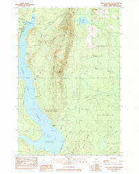
1984 Map of Squa Pan Lake East
USGS Topo · Published 1984About this map
Squa Pan Mountain dominates the central landscape of this Aroostook County survey, rising between the expansive Squa Pan Lake to the west and a series of stream valleys to the east. The 1980s terrain is characterized by its working timberlands and remote outposts, featuring the Bangor and Aroostook railroad line tracing the northern shore of the lake. Small points of settlement and access, such as Walker and Husdn Landing, dot the shoreline, providing entry to the water from the surrounding wooded townships.
Find a feature on this map
38 named features on this map. Tap any name to fly to it.
Don’t see what you’re looking for? This feature index may not catch every label — zoom into the map to look around manually.
Map Details
Editions of this 1984 Squa Pan Lake East Map
This is the sole edition of this map. No revisions or reprints were ever made.
Other maps of this area

1931 · Ashland
USGS Topo · 1:48,000

1934 · Ashland
USGS Topo · 1:62,500

1935 · Howe Brook
USGS Topo · 1:48,000

1935 · Presque Isle
USGS Topo · 1:62,500

1939 · Howe Brook
USGS Topo · 1:62,500

1940 · Oxbow
USGS Topo · 1:62,500

1942 · Oxbow
USGS Topo · 1:62,500

1953 · Ashland
USGS Topo · 1:62,500

1953 · Presque Isle
USGS Topo · 1:62,500

1954 · Howe Brook
USGS Topo · 1:62,500