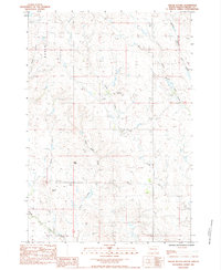
1983 Map of Squaw Buttes
USGS Topo · Published 1984About this map
Horse Butte and the surrounding high plains of Meade County define this western South Dakota landscape as it appeared in the early 1980s. The area is characterized by an intricate network of drainages, including the Middle Branch Pine Creek, West Branch Pine Creek, and the curiously named Frozen Man Creek. These waterways carve through the terrain, punctuated by distinct elevations like Zeff Butte and the primary Squaw Buttes formation.
Find a feature on this map
16 named features on this map. Tap any name to fly to it.
Don’t see what you’re looking for? This feature index may not catch every label — zoom into the map to look around manually.
Map Details
Editions of this 1983 Squaw Buttes Map
This is the sole edition of this map. No revisions or reprints were ever made.
Other maps of this area

1951 · Cedar Canyon
USGS Topo · 1:24,000

1951 · Maurine
USGS Topo · 1:24,000

1953 · Rapid City
USGS Topo · 1:250,000

1954 · Lemmon
USGS Topo · 1:250,000

1957 · Lemmon
USGS Topo · 1:250,000

1957 · Rapid City
USGS Topo · 1:250,000

1973 · Frozen Man Creek
USGS Topo · 1:24,000

1978 · Bull Run Creek
USGS Topo · 1:24,000

1980 · Beverly Creek
USGS Topo · 1:25,000

1983 · Opal West SE
USGS Topo · 1:24,000