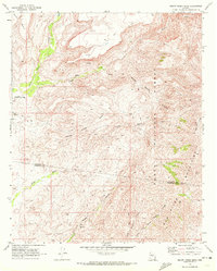
1969 Map of Squaw Creek Mesa
USGS Topo · Published 1972About this map
The Agua Fria River cuts through the western edge of this Arizona landscape, providing a critical riparian corridor for the growing community of Black Canyon City. To the east, the terrain rises sharply into the high plateaus of Black Mesa and Squaw Mesa, eventually reaching the boundary of the Tonto National Forest. This 1960s survey records the complex drainage system of the area, including Squaw Creek, Little Squaw Creek, and the New River, which carve deep canyons and gulches through the arid geology.
Find a feature on this map
23 named features on this map. Tap any name to fly to it.
Don’t see what you’re looking for? This feature index may not catch every label — zoom into the map to look around manually.
Map Details
Editions of this 1969 Squaw Creek Mesa Map
This is the sole edition of this map. No revisions or reprints were ever made.
Other maps of this area

1887 · Verde
USGS Topo · 1:250,000

1887 · Prescott
USGS Topo · 1:250,000

1892 · Verde
USGS Topo · 1:250,000

1892 · Prescott
USGS Topo · 1:250,000

1903 · Bradshaw Mountains
USGS Topo · 1:125,000

1929 · Turret Peak
USGS Topo · 1:125,000

1930 · Cave Creek
USGS Topo · 1:125,000

1933 · Turret Peak
USGS Topo · 1:125,000

1939 · Cave Creek
USGS Topo · 1:125,000

1947 · Bumblebee
USGS Topo · 1:62,500