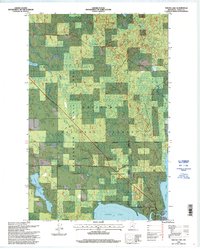
1996 Map of Squaw Lake
USGS Topo · Published 1998About this map
The Chippewa National Forest dominates this northern landscape, which transitions into the Blackduck State Forest to the west. Small settlements like Squaw Lake and Alwood appear as pockets of development within the expansive timberlands and wetlands of Itasca County. The presence of the Leech Lake Indian Reservation is marked by the Indian Reservation Administrative Boundary, reflecting the complex layering of federal, state, and tribal land management in the region.
Find a feature on this map
23 named features on this map. Tap any name to fly to it.
Don’t see what you’re looking for? This feature index may not catch every label — zoom into the map to look around manually.
Map Details
Editions of this 1996 Squaw Lake Map
This is the sole edition of this map. No revisions or reprints were ever made.
Other maps of this area

1919 · Rosy
USGS Topo · 1:62,500

1919 · Gemmell
USGS Topo · 1:62,500

1919 · Max
USGS Topo · 1:62,500

1919 · Bridgie
USGS Topo · 1:62,500

1924 · Bridgie
USGS Topo · 1:62,500

1954 · Bemidji
USGS Topo · 1:250,000

1957 · Bemidji
USGS Topo · 1:250,000

1958 · Bemidji
USGS Topo · 1:250,000

1971 · Squaw Lake
USGS Topo · 1:24,000

1971 · Dixon Lake
USGS Topo · 1:24,000