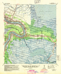
1942 Map of St. Bernard
USGS Topo · Published 1949About this map
The Mississippi River winds through the heart of the delta just before the mid-century, framing the deep historical layers of St. Bernard and Plaquemines Parishes. Along the river's English Turn Bend, traditional settlements like Braithwaite and Stella sit adjacent to the heavy infrastructure of the Sea Train Terminal. The map captures a landscape defined by water management and industry, from the Intra-Coastal Waterway in the north to the Kenilworth Oil Field and the Lake Lery Oil Derrick further south.
Find a feature on this map
61 named features on this map. Tap any name to fly to it.
Don’t see what you’re looking for? This feature index may not catch every label — zoom into the map to look around manually.
Map Details
Editions of this 1942 St. Bernard Map
This is the sole edition of this map. No revisions or reprints were ever made.
Other maps of this area

1891 · Spanish Fort
USGS Topo · 1:62,500

1891 · Pointe a La Hache
USGS Topo · 1:62,500

1891 · New Orleans
USGS Topo · 1:62,500

1892 · Barataria
USGS Topo · 1:62,500

1892 · Chef Menteur
USGS Topo · 1:62,500

1892 · St. Bernard
USGS Topo · 1:62,500

1892 · Pointe a La Hache
USGS Topo · 1:62,500

1893 · Rigolets
USGS Topo · 1:62,500

1893 · Shell Beach
USGS Topo · 1:62,500

1893 · Dime
USGS Topo · 1:62,500