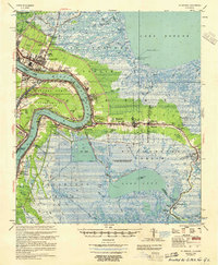
1955 Map of St. Bernard
USGS Topo · Published 1955About this map
The Mississippi River creates a dramatic crescent through this mid-century survey, defining the industrial and agricultural corridors of St. Bernard Parish and Plaquemines Parish. Along the river's eastern bank, a dense string of riverfront settlements like Chalmette, Violet, and Poydras follow the natural levee, hemmed in by the expansive wetlands of the Big Mar and the Forty Arpent Canal. This period shows the transition from traditional river-bound commerce to modern infrastructure, evidenced by the Alvin Callender Airport and the Sea Train Terminal near Scarsdale.
Find a feature on this map
95 named features on this map. Tap any name to fly to it.
Don’t see what you’re looking for? This feature index may not catch every label — zoom into the map to look around manually.
Map Details
Editions of this 1955 St. Bernard Map
This is the sole edition of this map. No revisions or reprints were ever made.
Other maps of this area

1891 · Spanish Fort
USGS Topo · 1:62,500

1891 · Pointe a La Hache
USGS Topo · 1:62,500

1891 · New Orleans
USGS Topo · 1:62,500

1892 · Barataria
USGS Topo · 1:62,500

1892 · Chef Menteur
USGS Topo · 1:62,500

1892 · St. Bernard
USGS Topo · 1:62,500

1892 · Pointe a La Hache
USGS Topo · 1:62,500

1893 · Rigolets
USGS Topo · 1:62,500

1893 · Shell Beach
USGS Topo · 1:62,500

1893 · Dime
USGS Topo · 1:62,500