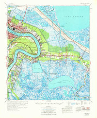
1969 Map of St. Bernard
USGS Topo · Published 1970About this map
Chalmette and its neighboring riverfront settlements define the cultural and industrial landscape along the Mississippi River in the late 1960s. This survey captures a period of suburban transition, shown in the residential grids of St Claude Heights and Chalmette Vista set against the sprawling U S Coast Guard Reservation. The map details the transition from the dense habitation near the river to the vast wetlands of the Big Mar and Lake Borgne, where a complex system of canals and bayous, including the massive Mississippi River Gulf Outlet, facilitates maritime commerce.
Find a feature on this map
77 named features on this map. Tap any name to fly to it.
Don’t see what you’re looking for? This feature index may not catch every label — zoom into the map to look around manually.
Map Details
Editions of this 1969 St. Bernard Map
This is the sole edition of this map. No revisions or reprints were ever made.
Other maps of this area

1891 · Spanish Fort
USGS Topo · 1:62,500

1891 · Pointe a La Hache
USGS Topo · 1:62,500

1891 · New Orleans
USGS Topo · 1:62,500

1892 · Barataria
USGS Topo · 1:62,500

1892 · Chef Menteur
USGS Topo · 1:62,500

1892 · St. Bernard
USGS Topo · 1:62,500

1892 · Pointe a La Hache
USGS Topo · 1:62,500

1893 · Rigolets
USGS Topo · 1:62,500

1893 · Shell Beach
USGS Topo · 1:62,500

1893 · Dime
USGS Topo · 1:62,500