
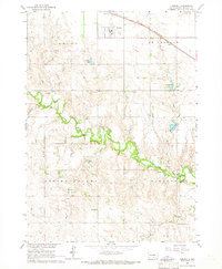
1964 Map of St. Charles
USGS Topo · Published 1965About this map
The settlement of St Charles serves as the focal point for this mid-1960s survey of Gregory County, South Dakota. Situated along the Chicago and North Western rail line, the community is surrounded by the organized townships of St Charles, Ellston, and Pleasant Valley. The landscape is defined by the sharp transition from the level rail corridor to the deeply incised drainage basins of the Missouri River system. The southern portion of the map follows the winding course of Ponca Creek, while the northern section is carved by Rock Creek and Burnt Creek. Hydrological features like Haisch Lake and Bonesteel Lake punctuate the northern plains. The presence of a Gaging Station on Ponca Creek reflects the mid-century focus on water management in the Missouri River Basin, capturing the area's rural character before modern land-use changes significantly altered these Missouri River tributaries.
Find a feature on this map
13 named features on this map. Tap any name to fly to it.
Don’t see what you’re looking for? This feature index may not catch every label — zoom into the map to look around manually.
Map Details
Editions of this 1964 St. Charles Map
This is the sole edition of this map. No revisions or reprints were ever made.
Other maps of this area

1951 · Butte NW
USGS Topo · 1:24,000

1951 · Naper
USGS Topo · 1:24,000

1955 · Mitchell
USGS Topo · 1:250,000

1955 · O'Neill
USGS Topo · 1:250,000

1959 · O'Neill
USGS Topo · 1:250,000

1959 · Mitchell
USGS Topo · 1:250,000

1964 · Herrick NW
USGS Topo · 1:24,000

1964 · Herrick NE
USGS Topo · 1:24,000

1964 · Whetstone Bay
USGS Topo · 1:24,000
1964 · Herrick
USGS Topo · 1:24,000