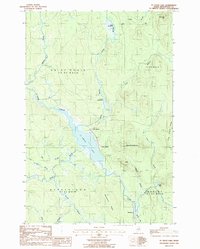
1986 Map of St. Croix Lake
USGS Topo · Published 1986About this map
St Croix Lake and its intricate drainage network dominate this corner of the Maine woods, where water defines the layout of the land. Small clusters of human activity are evident at Howe Brook and Weeksboro, while the presence of Little Canada near the lakeshore suggests a history of localized settlement or industrial outpost. The map preserves the complex hydrologic character of the region, specifically along the Howe Brook corridor with its Upper Deadwater and Lower Deadwater basins.
Find a feature on this map
29 named features on this map. Tap any name to fly to it.
Don’t see what you’re looking for? This feature index may not catch every label — zoom into the map to look around manually.
Map Details
Editions of this 1986 St. Croix Lake Map
This is the sole edition of this map. No revisions or reprints were ever made.
Other maps of this area

1935 · Howe Brook
USGS Topo · 1:48,000

1937 · Smyrna Mills
USGS Topo · 1:62,500

1939 · Howe Brook
USGS Topo · 1:62,500

1940 · Island Falls
USGS Topo · 1:62,500

1940 · Oxbow
USGS Topo · 1:62,500

1942 · Island Falls
USGS Topo · 1:62,500

1942 · Oxbow
USGS Topo · 1:62,500

1954 · Howe Brook
USGS Topo · 1:62,500

1954 · Presque Isle
USGS Topo · 1:250,000

1955 · Smyrna Mills
USGS Topo · 1:62,500
Featured Places
- Howe Brook, Saint Croix Township
- Little Canada, Saint Croix Township
- Weeksboro, Dudley Township
- Webbertown Township, ME
- Dudley Township, ME