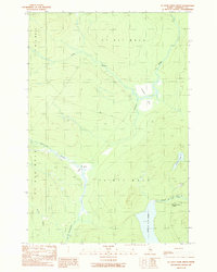
1989 Map of St. John Ponds Depot
USGS Topo · Published 1989About this map
St John Pond Depot serves as a lone namesake landmark in this remote corner of Somerset County, where the hydrology of the North Woods takes center stage. The landscape is defined by the headwaters and expansive wetlands of the St. John and Penobscot drainages, including the significant reach of Fifth St John Pond and the winding N Br Penobscot R. At the time of this 1980s survey, the area remained largely undeveloped, characterized by timber-management terrain divided into townships like T 6 R 17 W E L S. Local industry is evidenced by a Quarry and Gravel Pit near the water, while several named bogs such as Sweeney Bog and Little Bog punctuate the forest. This map captures the intricate network of brooks and streams, including Carry Brook and Abacotnetic Stream, that have long dictated movement through these northern Maine woods.
Find a feature on this map
20 named features on this map. Tap any name to fly to it.
Don’t see what you’re looking for? This feature index may not catch every label — zoom into the map to look around manually.
Map Details
Editions of this 1989 St. John Ponds Depot Map
This is the sole edition of this map. No revisions or reprints were ever made.
Other maps of this area

1954 · Baker Lake
USGS Topo · 1:62,500

1954 · St. John Pond
USGS Topo · 1:62,500

1954 · Presque Isle
USGS Topo · 1:250,000

1957 · Norris Brook
USGS Topo · 1:62,500

1957 · Hardwood Mountain
USGS Topo · 1:62,500

1958 · Presque Isle
USGS Topo · 1:250,000

1958 · Saint John Pond
USGS Topo · 1:62,500

1960 · Presque Isle
USGS Topo · 1:250,000

1962 · Baker Lake
USGS Topo · 1:62,500

1962 · Quebec
USGS Topo · 1:250,000