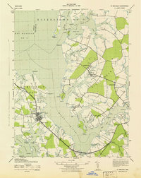
1943 Map of St. Michaels
USGS Topo · Published 1943About this map
The Eastern Shore of Maryland, particularly the complex maritime landscape surrounding St Michaels, is revealed here in the early 1940s. The map captures a transition point in the region's development, where the Baltimore and Eastern railroad corridor links small communities like Newcomb and Kirkham to the interior, while the deep cultural ties to the water remain evident in the numerous points and coves. To the north, the Wye River wraps around Wye Island, highlighting the intricate shoreline that defined local commerce and travel. Inland, smaller agrarian and mill settlements such as Tunis Mills, Copperville, and Unionville are clearly marked, providing a detailed look at the social geography of Talbot and Queen Anne's counties. The presence of St Stevens Church and local schoolhouses among these hamlets offers valuable locations for family historians tracing early twentieth-century residency patterns across this finger of land between the Miles River and Broad Creek.
Find a feature on this map
46 named features on this map. Tap any name to fly to it.
Don’t see what you’re looking for? This feature index may not catch every label — zoom into the map to look around manually.
Map Details
Editions of this 1943 St. Michaels Map
This is the sole edition of this map. No revisions or reprints were ever made.
Other maps of this area

1892 · Annapolis
USGS Topo · 1:62,500

1893 · Sharps Island
USGS Topo · 1:62,500

1898 · Choptank
USGS Topo · 1:125,000

1904 · St. Michaels
USGS Topo · 1:62,500

1904 · Annapolis
USGS Topo · 1:62,500

1904 · Sharps Island
USGS Topo · 1:62,500

1904 · Oxford
USGS Topo · 1:62,500

1908 · Choptank
USGS Topo · 1:125,000

1942 · Tilghman
USGS Topo · 1:31,680

1942 · Oxford
USGS Topo · 1:31,680