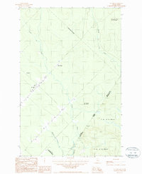
1987 Map of St. Omer
USGS Topo · Published 1987About this map
St. Omer sits at the heart of this 1980s borderlands survey, where the international boundary between Québec and Maine follows a series of straight lines and natural watercourses. The landscape is defined by the steep rises of Montagne du Rochu and Montagne des Cinq Milles, interspersed with a network of drainage including Rivière du Rochu and Rivière des Cinq Milles. Settlement is concentrated along the border road, featuring the small cluster at St. Omer with its Cem and Sew Disp, as well as the named locations of Cote a Deroy and Depoteir. This map illustrates the intersection of administrative divisions like T 16 R 15 Wels and the Municipalité de Saint-Omer, showing the sparse, utilitarian development of this northern timber and border region before the turn of the twenty-first century.
Find a feature on this map
18 named features on this map. Tap any name to fly to it.
Don’t see what you’re looking for? This feature index may not catch every label — zoom into the map to look around manually.
Map Details
Editions of this 1987 St. Omer Map
This is the sole edition of this map. No revisions or reprints were ever made.
Other maps of this area

1954 · Presque Isle
USGS Topo · 1:250,000

1955 · Little East Lake
USGS Topo · 1:62,500

1955 · Depot Lake
USGS Topo · 1:62,500

1955 · Seven Islands
USGS Topo · 1:62,500

1958 · Presque Isle
USGS Topo · 1:250,000

1960 · Presque Isle
USGS Topo · 1:250,000

1962 · Edmundston
USGS Topo · 1:250,000

1976 · East Lake
USGS Topo · 1:24,000

1976 · East Lake SE
USGS Topo · 1:24,000
1976 · St. Pamphile
USGS Topo · 1:24,000