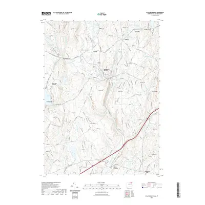
2021 Map of Stafford Springs
USGS Topo · Published 2021About this map
Stafford Springs serves as the industrial and civic heart of this Tolland County landscape, where the Middle River meets Furnace Brook. The area's manufacturing legacy is visible in the string of settlements along the water, including Staffordville, Hydeville, and the historic railroad siding at Orcutts. Beyond the mill villages, the terrain rises into significant uplands such as Rockwell Hill and Crow Hill, while the western edge is defined by the recreational and residential clusters around Crystal Lake. This 2021 update documents a complex network of conservation lands and recreation, including the Nipmuck Forest Trl and Shenipsit Forest Trl. Genealogists will find a high density of burial sites recorded, from the Old Stafford Street Cem to the Skungamaug Cem, illustrating the deep-rooted settlement patterns that have persisted from the colonial era through the modern day.
Find a feature on this map
81 named features on this map. Tap any name to fly to it.
Don’t see what you’re looking for? This feature index may not catch every label — zoom into the map to look around manually.
Map Details
Editions of this 2021 Stafford Springs Map
This is the sole edition of this map. No revisions or reprints were ever made.
Other maps of this area

1887 · Brookfield
USGS Topo · 1:62,500

1887 · Palmer
USGS Topo · 1:62,500

1889 · Palmer
USGS Topo · 1:62,500

1890 · Brookfield
USGS Topo · 1:62,500

1892 · Woodstock
USGS Topo · 1:62,500

1892 · Tolland
USGS Topo · 1:62,500

1893 · Palmer
USGS Topo · 1:62,500

1893 · Brookfield
USGS Topo · 1:62,500

1908 · Ware
USGS Topo · 1:125,000

1915 · Brookfield
USGS Topo · 1:62,500