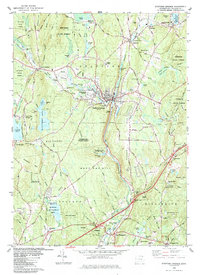
1983 Map of Stafford Springs
USGS Topo · Published 1984About this map
The Willimantic River corridor serves as the industrial and transportation spine for this portion of Tolland County, anchoring the town center of Stafford Springs. The Central Vermont Railroad follows the river's winding path through the valley, passing near the Rhode Island Millponds and several local reservoirs like Warren Pond. The landscape is a mix of dense forest and valley settlements, with Shenipsit State Forest and Nye-Holman State Forest covering significant portions of the uplands. The distribution of schools and cemeteries, such as the Stafford St Cem and Middle Sch, reflects the cluster of 19th-century village growth around water power and transit. Evidence of local industry is seen in the numerous extraction sites, including the Frink Sand and Gravel Pit and various other gravel pits located near West Willington and Staffordville.
Find a feature on this map
113 named features on this map. Tap any name to fly to it.
Don’t see what you’re looking for? This feature index may not catch every label — zoom into the map to look around manually.
Map Details
Editions of this 1983 Stafford Springs Map
This is the sole edition of this map. No revisions or reprints were ever made.
Other maps of this area

1887 · Brookfield
USGS Topo · 1:62,500

1887 · Palmer
USGS Topo · 1:62,500

1889 · Palmer
USGS Topo · 1:62,500

1890 · Brookfield
USGS Topo · 1:62,500

1892 · Woodstock
USGS Topo · 1:62,500

1892 · Tolland
USGS Topo · 1:62,500

1893 · Palmer
USGS Topo · 1:62,500

1893 · Brookfield
USGS Topo · 1:62,500

1908 · Ware
USGS Topo · 1:125,000

1915 · Brookfield
USGS Topo · 1:62,500