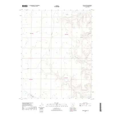
2019 Map of Stage Canyon
USGS Topo · Published 2019About this map
Stage Canyon and the surrounding high country of Las Animas County dominate this 2019 landscape, where deep drainages and isolated springs define the topography. The arid terrain is etched by complex watercourse systems, including Lockwood Arroyo and its eponymous Lockwood Canyon in the southwest. High points like Cedar Hill and the Black Hills overlook a network of seasonal washes and steep-walled breaks such as Sugarloaf Canyon and Welsh Canyon. Connectivity across this sparsely populated region is maintained by the north-south transit of Red Rock Rd. A vital point of interest for local history and wildlife, Sugarloaf Spring appears in the northeast, tucked near the Black Hills, providing a rare water source in a landscape otherwise defined by dry beds like Red Rock Canyon.
Find a feature on this map
15 named features on this map. Tap any name to fly to it.
Don’t see what you’re looking for? This feature index may not catch every label — zoom into the map to look around manually.
Map Details
Editions of this 2019 Stage Canyon Map
This is the sole edition of this map. No revisions or reprints were ever made.
Other maps of this area

1891 · Timpas
USGS Topo · 1:125,000

1891 · Mesa De Maya
USGS Topo · 1:125,000

1893 · Mesa de Maya
USGS Topo · 1:125,000

1894 · Timpas
USGS Topo · 1:125,000

1955 · La Junta
USGS Topo · 1:250,000

1958 · La Junta
USGS Topo · 1:250,000

1968 · La Junta
USGS Topo · 1:250,000

1972 · Johnson Canyon
USGS Topo · 1:24,000

1972 · Doss Canyon North
USGS Topo · 1:24,000

1972 · Packers Gap
USGS Topo · 1:24,000