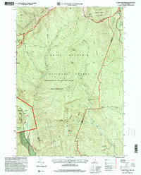
1995 Map of Stairs Mountain
USGS Topo · Published 2000About this map
The high peaks of the Presidential Range define this portion of the White Mountain National Forest, where the topography is shaped by ancient glacial cirques like Oaks Gulf and the Gulf of Slides. Human activity is primarily centered around the early transit corridors of Crawford Notch, where the Willey House PO and the settlement at Bemis sit along the Saco River. The map illustrates a landscape of major land grants, including Sargents Purchase, Hadleys Purchase, and Bean's Purchase, reflecting the historical division of these mountain tracts.
Find a feature on this map
68 named features on this map. Tap any name to fly to it.
Don’t see what you’re looking for? This feature index may not catch every label — zoom into the map to look around manually.
Map Details
Editions of this 1995 Stairs Mountain Map
This is the sole edition of this map. No revisions or reprints were ever made.
Other maps of this area

1893 · Mt. Washington
USGS Topo · 1:62,500

1893 · Gorham
USGS Topo · 1:62,500

1894 · North Conway
USGS Topo · 1:62,500

1895 · Crawford Notch
USGS Topo · 1:62,500

1896 · Mt. Washington
USGS Topo · 1:62,500

1896 · Crawford Notch
USGS Topo · 1:62,500

1896 · North Conway
USGS Topo · 1:62,500

1896 · Gorham
USGS Topo · 1:62,500

1935 · Mt. Washington
USGS Topo · 1:62,500

1937 · Gorham
USGS Topo · 1:48,000