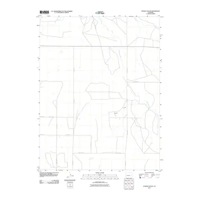
2010 Map of Stanley Gulch
USGS Topo · Published 2010About this map
South Rush Creek winds through this section of the high plains in Lincoln County, carving a subtle path across a landscape defined by its grid of rural transport. The drainage of Stanley Gulch meets the creek in the eastern half of the quadrangle, serving as a primary topographical landmark in an area primarily organized around agricultural section lines. This 2010 digital-age survey captures the rectilinear layout of the high prairie, where State Highway 94 cuts a straight east-west line across the northern terrain. The map records a system of maintained gravel and dirt paths including County Road Y and County Road W, reflecting the enduring settlement pattern of eastern Colorado's ranching and farming country.
Find a feature on this map
13 named features on this map. Tap any name to fly to it.
Don’t see what you’re looking for? This feature index may not catch every label — zoom into the map to look around manually.
Map Details
Editions of this 2010 Stanley Gulch Map
This is the sole edition of this map. No revisions or reprints were ever made.
Other maps of this area

1889 · Sanborn
USGS Topo · 1:125,000

1891 · Sanborn
USGS Topo · 1:125,000

1891 · Arroyo
USGS Topo · 1:125,000

1893 · Arroyo
USGS Topo · 1:125,000

1893 · Sanborn
USGS Topo · 1:125,000

1954 · Lamar
USGS Topo · 1:250,000

1958 · Lamar
USGS Topo · 1:250,000

1975 · Stanley Gulch
USGS Topo · 1:24,000

1977 · Punkin Center
USGS Topo · 1:24,000
1978 · Beckman Lake
USGS Topo · 1:24,000