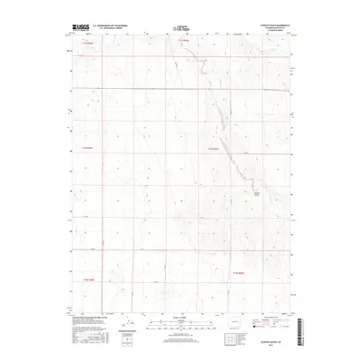
2016 Map of Stanley Gulch
USGS Topo · Published 2016About this map
Stanley Gulch defines the eastern portion of this high plains landscape, situated in Lincoln County. The drainage network is dominated by the winding course of S Rush Cr, which meanders north toward its confluence with Rush Cr. This 2016 survey illustrates a strictly organized section-line road system characteristic of the Colorado plains, where local transit is facilitated by a grid including Co RD 29, Co RD 27, and Co RD 25. The map provides a detailed view of the terrain and township boundaries, such as t14s r55w, showing the expansive, sparsely populated geography of the region. This is a purely rural expanse, focused on the natural topography and the surveyed infrastructure that supports the local agricultural economy.
Find a feature on this map
17 named features on this map. Tap any name to fly to it.
Don’t see what you’re looking for? This feature index may not catch every label — zoom into the map to look around manually.
Map Details
Editions of this 2016 Stanley Gulch Map
This is the sole edition of this map. No revisions or reprints were ever made.
Other maps of this area

1889 · Sanborn
USGS Topo · 1:125,000

1891 · Sanborn
USGS Topo · 1:125,000

1891 · Arroyo
USGS Topo · 1:125,000

1893 · Arroyo
USGS Topo · 1:125,000

1893 · Sanborn
USGS Topo · 1:125,000

1954 · Lamar
USGS Topo · 1:250,000

1958 · Lamar
USGS Topo · 1:250,000

1975 · Stanley Gulch
USGS Topo · 1:24,000

1977 · Punkin Center
USGS Topo · 1:24,000
1978 · Beckman Lake
USGS Topo · 1:24,000