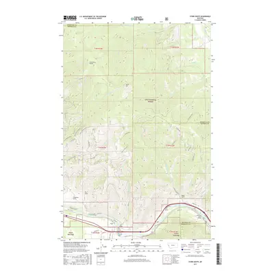
2017 Map of Stark South
USGS Topo · Published 2017About this map
Cyr sits along the southern bend of the Clark Fork river, marking a point of valley settlement within the expansive timberlands of the Lolo National Forest. This section of the Mineral and Missoula County border is defined by significant elevation changes, rising from the river floor toward the towering Stark Mtn and the prominent Ninemile Divide. The landscape is etched with deep drainages such as Bear Cr, Duff Cr, and Freezeout Gulch, reflecting the complex topography of the Bitterroot range. Infrastructure is concentrated near the water, with the Cyr Bridge and Clark Fork River Bridge providing essential crossings for Old Hwy 10 W and the modern interstate corridor. Higher elevations are dominated by administrative and fire-management landmarks like Tower 12 and Tower 11, which oversee the vast stands of the Lolo National Forest.
Find a feature on this map
58 named features on this map. Tap any name to fly to it.
Don’t see what you’re looking for? This feature index may not catch every label — zoom into the map to look around manually.
Map Details
Editions of this 2017 Stark South Map
This is the sole edition of this map. No revisions or reprints were ever made.
Other maps of this area

1911 · Lolo
USGS Topo · 1:250,000

1912 · Missoula
USGS Topo · 1:125,000

1913 · Lolo
USGS Topo · 1:250,000

1956 · Wallace
USGS Topo · 1:250,000

1956 · Hamilton
USGS Topo · 1:250,000

1959 · Hamilton
USGS Topo · 1:250,000

1959 · Tarkio
USGS Topo · 1:62,500

1959 · Alberton
USGS Topo · 1:62,500

1960 · Wallace
USGS Topo · 1:250,000

1960 · Hamilton
USGS Topo · 1:250,000