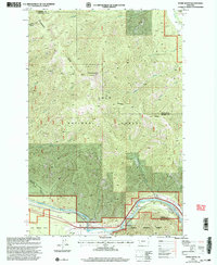
1999 Map of Stark South
USGS Topo · Published 2003About this map
The Clark Fork river carves through the southern edge of this Montana landscape, creating a vital transportation corridor defined by the tunnel and multiple access points for river use. In this remote section of the Lolo National Forest, the topography is dominated by the massive Ninemile Divide which separates the many drainages of Ninemile Creek and Nemote Creek. The high point of the region is anchored by the Stark Mountain Lookout, providing a strategic vantage over the complex system of gulches including Freezout Gulch and Dry Gulch. Settlement is sparse, limited to the small communities of Stark and Bestwick near the riverbanks. The presence of the Natural Pier Bridge and several designated fishing sites like St John Fishing Access indicates the shift from early industrial rail and road use toward recreational value in the late 20th century.
Find a feature on this map
31 named features on this map. Tap any name to fly to it.
Don’t see what you’re looking for? This feature index may not catch every label — zoom into the map to look around manually.
Map Details
Editions of this 1999 Stark South Map
This is the sole edition of this map. No revisions or reprints were ever made.
Other maps of this area

1911 · Lolo
USGS Topo · 1:250,000

1912 · Missoula
USGS Topo · 1:125,000

1913 · Lolo
USGS Topo · 1:250,000

1956 · Wallace
USGS Topo · 1:250,000

1956 · Hamilton
USGS Topo · 1:250,000

1959 · Hamilton
USGS Topo · 1:250,000

1959 · Tarkio
USGS Topo · 1:62,500

1959 · Alberton
USGS Topo · 1:62,500

1960 · Wallace
USGS Topo · 1:250,000

1960 · Hamilton
USGS Topo · 1:250,000