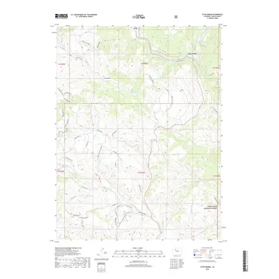
2019 Map of State Bridge
USGS Topo · Published 2019About this map
State Bridge and the small settlement of Bond serve as the primary human touchpoints in this reach of Eagle County, where the Colorado River carves through the terrain. The map documents a complex network of access roads, from Co RD 41a to numerous Bureau of Land Management routes like BLM Route 8514, illustrating the managed use of public lands. High-elevation features such as Horse Mtn and Windy Point overlook a landscape punctuated by seasonal water sources and engineered improvements like the Welsh Reservoir. The southeastern portion is defined by the White River National Forest, where the topography drops into Denison Draw and meets the Piney River. This 2019 survey reflects the modern intersection of ranching infrastructure, recreational access, and protected forest boundaries, preserving the names of remote drainages like Cabin Gulch and High Trail Gulch.
Find a feature on this map
62 named features on this map. Tap any name to fly to it.
Don’t see what you’re looking for? This feature index may not catch every label — zoom into the map to look around manually.
Map Details
Editions of this 2019 State Bridge Map
This is the sole edition of this map. No revisions or reprints were ever made.
Other maps of this area

1957 · Leadville
USGS Topo · 1:250,000

1959 · Leadville
USGS Topo · 1:250,000

1960 · Leadville
USGS Topo · 1:250,000

1962 · Leadville
USGS Topo · 1:250,000

1962 · Wolcott
USGS Topo · 1:24,000

1962 · Eagle
USGS Topo · 1:24,000

1962 · Edwards
USGS Topo · 1:24,000

1964 · Leadville
USGS Topo · 1:250,000
1972 · Mc Coy
USGS Topo · 1:24,000

1972 · Blue Hill
USGS Topo · 1:24,000