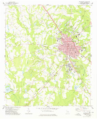
1978 Map of Statesboro
USGS Topo · Published 1978About this map
The growing college town of Statesboro serves as the hub of this late-1970s survey, characterized by its grid of established streets like Main St and College Ave. The campus of Georgia Southern College anchors the south side of town, while the Central of Georgia railroad cuts diagonally through the landscape, marking the historic industrial and transit corridor. To the southwest, the small settlement of Jimps sits near the winding course of Lotts Creek.
Find a feature on this map
67 named features on this map. Tap any name to fly to it.
Don’t see what you’re looking for? This feature index may not catch every label — zoom into the map to look around manually.
Map Details
Editions of this 1978 Statesboro Map
This is the sole edition of this map. No revisions or reprints were ever made.
Other maps of this area

1918 · Oliver
USGS Topo · 1:62,500

1920 · Statesboro
USGS Topo · 1:62,500

1920 · Oliver
USGS Topo · 1:62,500

1921 · Brooklet
USGS Topo · 1:62,500

1921 · Rocky Ford
USGS Topo · 1:62,500

1943 · Brooklet
USGS Topo · 1:62,500

1943 · Rocky Ford
USGS Topo · 1:62,500

1943 · Millen
USGS Topo · 1:125,000

1943 · Statesboro
USGS Topo · 1:62,500

1943 · Oliver
USGS Topo · 1:62,500