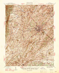
1947 Map of Staunton
USGS Topo · Published 1947About this map
Staunton serves as the central hub for this mid-century survey of the Shenandoah Valley, where the convergence of the Chesapeake and Ohio, Baltimore and Ohio, and Norfolk and Western railroads illustrates the city's role as a vital transportation node. The landscape is dotted with numerous rural congregations and burying grounds, such as Jerusalem Chapel, Hebron Ch, and the Glebe Cem, reflecting a deeply rooted community structure. Industrial relics like Trimbles Mill and Folly Mills sit along the winding watercourses of the Middle River and South River, showing the legacy of water-powered commerce in Augusta County. From the heights of Little North Mountain and Crawford Knob down to the settlements of Swoope and Greenville, the map provides an intricate look at the post-war valley before the expansion of the modern interstate system, maintaining a high density of named family-led landmarks and local schools like College Park.
Find a feature on this map
79 named features on this map. Tap any name to fly to it.
Don’t see what you’re looking for? This feature index may not catch every label — zoom into the map to look around manually.
Map Details
Editions of this 1947 Staunton Map
2 editions found

Other maps of this area

1892 · Buckingham
USGS Topo · 1:125,000

1892 · Harrisonburg
USGS Topo · 1:125,000

1894 · Staunton
USGS Topo · 1:125,000

1894 · Lexington
USGS Topo · 1:125,000

1924 · Mc Dowell
USGS Topo · 1:62,500

1932 · Lexington
USGS Topo · 1:48,000

1934 · Waynesboro
USGS Topo · 1:48,000

1936 · Vesuvius
USGS Topo · 1:48,000

1937 · Lexington
USGS Topo · 1:62,500

1939 · Waynesboro
USGS Topo · 1:62,500