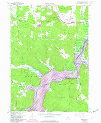
1962 Map of Steamburg
USGS Topo · Published 1980About this map
The Allegheny Reservoir dominates the southern reaches of this landscape, its waters filling the valley where the Allegheny River flows toward the Pennsylvania state line. This 1960s-era topography, updated in 1980, shows the complex relationship between protected lands and historical settlements. Large tracts are dedicated to the Allegany State Park and the Allegany Indian Reservation, highlighting a region shaped by conservation and indigenous heritage. To the north, the hamlet of Steamburg serves as a local hub, featuring the Steamburg Cem and the nearby Cold Spring Sch No 3. The terrain is marked by significant elevations like Johnny Watt Hill and Round Top, while the Conrail line and numerous small runs, such as Hotchkiss Hollow Run and Sawmill Run, trace the natural contours of the Cattaraugus County countryside.
Find a feature on this map
51 named features on this map. Tap any name to fly to it.
Don’t see what you’re looking for? This feature index may not catch every label — zoom into the map to look around manually.
Map Details
Editions of this 1962 Steamburg Map
3 editions found
Other maps of this area

1905 · Jamestown
USGS Topo · 1:62,500

1906 · Warren
USGS Topo · 1:62,500

1907 · Warren
USGS Topo · 1:62,500

1908 · Warren
USGS Topo · 1:62,500

1922 · Randolph
USGS Topo · 1:62,500

1923 · Randolph
USGS Topo · 1:62,500

1936 · Kinzua
USGS Topo · 1:48,000

1941 · Kinzua
USGS Topo · 1:62,500

1942 · Jamestown
USGS Topo · 1:62,500

1943 · Randolph
USGS Topo · 1:62,500