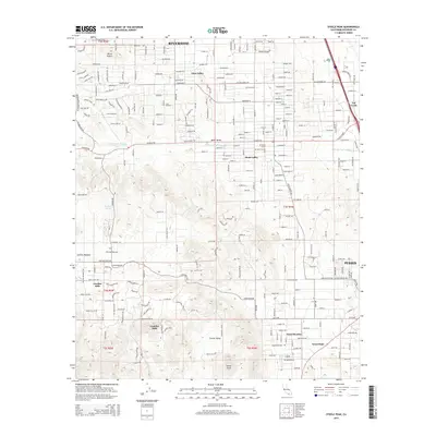
2015 Map of Steele Peak
USGS Topo · Published 2015About this map
Steele Peak and the surrounding high desert terrain define this landscape south of Riverside, where small settlements and rural subdivisions are scattered across the arid valleys. The Colorado River Aqueduct is a major engineering feature on this sheet, winding through the northern portion and disappearing into the Val Verde Tunnel. Communities such as Glen Valley, Mead Valley, and Val Verde occupy the lower elevations, while Good Hope and Good Meadow are situated further south toward the foothills. The terrain transitions from the relatively flat valley floors to more complex features like the Gavilan Hills and Gavilan Plateau to the west. Local landmarks such as Three Sisters and Harford Spring indicate the rugged character of the unpopulated gaps between these growing communities. Tracing the network of local roads like Cajalco Rd and Santa Rosa Rd reveals the residential expansion occurring in these formerly open spaces.
Find a feature on this map
154 named features on this map. Tap any name to fly to it.
Don’t see what you’re looking for? This feature index may not catch every label — zoom into the map to look around manually.
Map Details
Editions of this 2015 Steele Peak Map
This is the sole edition of this map. No revisions or reprints were ever made.
Other maps of this area

1901 · Southern California Sheet No. 1
USGS Topo · 1:250,000

1901 · Elsinore
USGS Topo · 1:125,000

1901 · Riverside
USGS Topo · 1:62,500

1904 · Southern California Sheet No. 1
USGS Topo · 1:250,000

1942 · Lake Elsinore
USGS Topo · 1:62,500
1942 · Riverside and Vicinity
USGS Topo · 1:31,680

1942 · Murrieta
USGS Topo · 1:62,500

1942 · Riverside
USGS Topo · 1:62,500

1942 · Perris
USGS Topo · 1:62,500

1943 · Perris
USGS Topo · 1:62,500