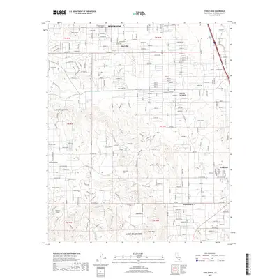
2018 Map of Steele Peak
USGS Topo · Published 2018About this map
Steele Peak overlooks a diverse landscape where suburban development meets industrial water infrastructure and military installations in Riverside County. The northern sector is defined by the March Air Reserve Base and the emerging residential grids of Glen Valley and Mead Valley, while the Colorado River Aqueduct carves a significant path through the terrain, including the subterranean Val Verde Tunnel. This 2018 survey captures the interface of established settlements like Val Verde and Good Hope with the dramatic topography of the Gavilan Plateau and the Three Sisters peaks. To the west, the map reaches the edges of Lake Mathews and the rugged Alberhill Canyon, providing a detailed record of the area's natural drainages such as Arroyo Del Toro alongside modern transport corridors like Mariposa Ave and Cajalco Rd.
Find a feature on this map
41 named features on this map. Tap any name to fly to it.
Don’t see what you’re looking for? This feature index may not catch every label — zoom into the map to look around manually.
Map Details
Editions of this 2018 Steele Peak Map
This is the sole edition of this map. No revisions or reprints were ever made.
Other maps of this area

1901 · Southern California Sheet No. 1
USGS Topo · 1:250,000

1901 · Elsinore
USGS Topo · 1:125,000

1901 · Riverside
USGS Topo · 1:62,500

1904 · Southern California Sheet No. 1
USGS Topo · 1:250,000

1942 · Lake Elsinore
USGS Topo · 1:62,500
1942 · Riverside and Vicinity
USGS Topo · 1:31,680

1942 · Murrieta
USGS Topo · 1:62,500

1942 · Riverside
USGS Topo · 1:62,500

1942 · Perris
USGS Topo · 1:62,500

1943 · Perris
USGS Topo · 1:62,500