1982 Map of Steens Mtn
USGS Topo · Published 1983About this map
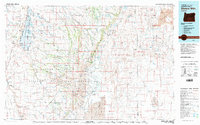
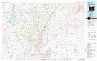
Steens Mountain National Recreation Lands dominate this high-desert region of southeastern Oregon, showcasing a landscape of dramatic geologic transitions. The eastern face of Steens Mountain drops sharply into the expansive Alvord Desert, a stark contrast to the riparian corridors of the Blitzen River and Donner und Blitzen River to the west. Within this remote terrain, the settlement of Frenchglen serves as a lone outpost, connected by the Frenchglen-Steens Road. The map documents critical conservation and geothermal areas, including the southern reaches of the Malheur National Wildlife Refuge and the localized Alvord Hot Springs. From the volcanic Saddle Butte Lava Field in the northeast to the alkali flats of Coyote Lake, the survey captures a complex network of seasonal creeks and drainage basins defining Harney County in the early 1980s.
Find a feature on this map
33 named features on this map. Tap any name to fly to it.
Don’t see what you’re looking for? This feature index may not catch every label — zoom into the map to look around manually.
Map Details
Editions of this 1982 Steens Mtn Map
2 editions found
Other maps of this area

1955 · Jordan Valley
USGS Topo · 1:250,000

1955 · Burns
USGS Topo · 1:250,000

1955 · Adel
USGS Topo · 1:250,000

1955 · Boise
USGS Topo · 1:250,000

1957 · Adel
USGS Topo · 1:250,000

1957 · Jordan Valley
USGS Topo · 1:250,000

1958 · Burns
USGS Topo · 1:250,000

1958 · Boise
USGS Topo · 1:250,000

1958 · Adel
USGS Topo · 1:250,000

1958 · Jordan Valley
USGS Topo · 1:250,000