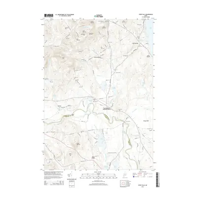
2014 Map of Steep Falls
USGS Topo · Published 2014About this map
The Saco River meanders through the heart of this landscape, marking the boundary between Cumberland and York counties and defining the industrial and agricultural patterns of the region. This 2014 survey captures a dense network of family-named cemeteries and rural settlements that reflect generations of Maine history. Clusters of burial grounds like the Dunn Nason Guptill Cem and Emerson Thorne Cem are scattered across the terrain, while the community of East Baldwin Mattocks Station serves as a key geographical point near the river's bend. To the north, the waters of Sebago Lake reach the corner of the map near East Sebago, supported by local catchments such as Fitch Mill Pond and Woods Millpond. The topography is shaped by prominent heights including Douglas Mountain and Dykes Mountain, overlooking a mix of aviation at Limington-Harmon Airport and the cryptic crossroads of Ruin Corner.
Find a feature on this map
111 named features on this map. Tap any name to fly to it.
Don’t see what you’re looking for? This feature index may not catch every label — zoom into the map to look around manually.
Map Details
Editions of this 2014 Steep Falls Map
This is the sole edition of this map. No revisions or reprints were ever made.
Other maps of this area

1891 · Buxton
USGS Topo · 1:62,500

1891 · Newfield
USGS Topo · 1:62,500

1892 · Buxton
USGS Topo · 1:62,500

1893 · Buxton
USGS Topo · 1:62,500

1893 · Newfield
USGS Topo · 1:62,500

1896 · Sebago
USGS Topo · 1:62,500

1910 · Kezar Falls
USGS Topo · 1:48,000

1911 · Kezar Falls
USGS Topo · 1:62,500

1933 · Newfield
USGS Topo · 1:48,000

1937 · Newfield
USGS Topo · 1:62,500