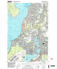
1997 Map of Steilacoom
USGS Topo · Published 2003About this map
The waters of Puget Sound and American Lake define this detailed landscape of suburban growth and military infrastructure in Pierce County. The map documents the high density of civic and medical institutions that characterize the area, from the Western Washington State Hospital to the American Lake Veterans Hospital. These facilities sit alongside extensive military grounds, including a portion of the Mcchord Air Force Base and the Fort Lewis North Post.
Find a feature on this map
126 named features on this map. Tap any name to fly to it.
Don’t see what you’re looking for? This feature index may not catch every label — zoom into the map to look around manually.
Map Details
Editions of this 1997 Steilacoom Map
This is the sole edition of this map. No revisions or reprints were ever made.
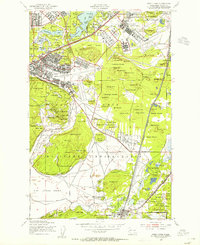
Other maps of this area

1897 · Tacoma
USGS Topo · 1:125,000

1900 · Tacoma
USGS Topo · 1:125,000

1940 · Anderson Island
USGS Topo · 1:62,500

1941 · Tacoma South
USGS Topo · 1:62,500

1942 · Gig Harbor
USGS Topo · 1:62,500

1943 · Gig Harbor
USGS Topo · 1:62,500

1944 · Tacoma South
USGS Topo · 1:62,500

1948 · Anderson Island
USGS Topo · 1:62,500
1948 · Fort Lewis
USGS Topo · 1:24,000

1948 · Nisqually
USGS Topo · 1:24,000